Risk assessment for wildfires
Much research is being conducted to improve risk assessment methodologies regarding wildfires in the Netherlands. For example, the Netherlands Environmental Assessment Agency (PBL) is assessing the potential impacts on people, finances, nature, and cultural assets. Until the methodology and results of the PBL study are availalbe, it is recommended to assess wildfire risk by looking at how susceptible an area is to fire, using the wildfire susceptibility map developed by Wageningen Environmental Research and Deltares (PDF), see data access.
Please note that this method is a susceptibility assessment, not a risk assessment. To perform a risk assessment, besides susceptibility all layers of the multi layer safety principle should be considered. This includes public awareness of wildfires, wildfire control and management, crisis management measures (e.g. fire brigade and resource availability), and recovery options. Additionally, wildfire risk assessments should include climate projections and socioeconomic changes, such as the wildland-urban interface.
Wildfire susceptibility assessment
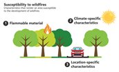
As stated in the Deltares report (PDF), the wildfire susceptibility map indicates the likelihood of a wildfire occurring, as was discussed in the definition section, and combines the following conditions:
- Amount of flammable material
- Climate-specific qualities, including the potential maximum precipitation deficit, average lowest groundwater level, and soil type.
- Location-specific qualities, such as recreation, wildlife bridges and parking lots.
For each of these conditions, thresholds are determined classifying the wildfire susceptibility in low, medium and high.
Wildfires susceptibility assessment for buildings
For the real estate sector, the Framework for Climate Adaptive Buildings (FCAB) by the Dutch Green Building Council uses the wildfire susceptibility map to assess the hazard score of buildings in a portfolio. The table below shows how the wildfire susceptibility data is transposed to a hazard score. During the development of the FCAB, the experts indicated that for individual buildings, a low wildfire susceptibility score equates to no risk.
| Wildfire susceptibility score | Hazard score |
|---|---|
| 3 | High |
| 2 | Medium |
| 1 | No risk |
| No data | No risk |
For the FCAB, only the wildfire susceptibility map is used for 2050 conditions with a high climate scenario (i.e., SSP5-8.5, or Royal Netherlands Meteorological Institute’s (KNMI) WH scenario from 2014). The map is also available for current conditions.
While the method has not been developed for other assets than buildings, the wildfire susceptibility map can still be used for other purposes. However, for the assessment of nature or agriculture, the wildfire susceptibility score of one should still be considered as a low risk, instead of no risk.
It should be noted that the wildfire susceptibility data has a relatively coarse resolution of 250 by 250 metres. Please see the Assumptions and limitations for further information.