Risk assessment for groundwater floods
When assessing groundwater flood risk, it is important to look at both the current situation and future risks caused by climate change. The best way to estimate future risks is to start by examining the present conditions. This is because areas experiencing groundwater flooding now are often the same places that will be affected in the future.
The risk of groundwater flood differs between built-up and non-built-up areas, as the causes and effects can vary. Following the Climate Impact Atlas, the next section explains how to assess risk in built-up areas, though the approach may also be useful for non-built-up regions.
Current situation
Groundwater flood risk for built-up areas can be estimated by considering three key factors: the normative groundwater level, the drainage depth, and the maximum groundwater level.
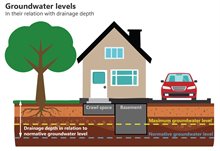
The normative groundwater level is the reference groundwater level used when planning built-up areas. Based on this level, in the building process, a drainage depth for the area is established and applied. This is the minimum required distance between the ground surface and the normative groundwater level. In built-up areas, different land uses require specific drainage depths, as shown in the table below.
If the drainage depth is small, crawl spaces and non-watertight basements located just above normative groundwater level are particularly vulnerable to flooding, as the safety margin is minimal.
| Land use | Drainage depth (metres below surface level) |
|---|---|
| Residential streets | 0.7 |
| Main roads | 1.0 |
| Gardens and public green spaces | 0.5 |
| Buildings without crawl space | 0.4 |
| Buildings with crawl space | 0.8 |
To assess the potential impact of groundwater flooding, measurements or an estimation of the maximum groundwater level in an area is important. Especially during prolonged heavy rainfall, groundwater levels may rise above the normative groundwater level, exceeding the drainage depth and potentially leading to flooding in basements and crawl spaces.
The difference between the maximum groundwater level and normative groundwater level shows how much higher the groundwater can rise beyond what buildings are typically designed to cope with. However, this alone does not determine whether flooding will occur, as this also depends on building characteristics.
An indication of the risk posed by high groundwater levels can be obtained by comparing the maximum highest groundwater level with building characteristics. Vulnerable buildings have, for instance, an uninsulated non-waterproof wooden ground floor or a non-waterproof basement. If the maximum highest groundwater level exceeds the height of the bottom of the crawl space or the height of the basement floor, nuisances or damages are to be expected.
Future situation
A dedicated dataset is available that projects the effect of climate change on groundwater flood risks in built-up areas. This dataset indicates the degree to which the probability of excessive groundwater levels that cause problems will increase between now and 2050.
To better understand changes in future groundwater flood risk, it is recommended to use this dataset alongside existing data on normative and maximum groundwater levels from the current situation. In general, in areas where the hazard of groundwater flooding is already high in the current situation, the probability of groundwater flooding caused by climate change, also increases.