Ga naar de inhoud
Logo Dutch Climate Risk Portal (naar homepage)
Direct naar
  • News
  • About us
  • FAQ
  • Updates
  • Home
  • Climate risk
  • Hazards & Data
  • Tools & Resources
  • Helpdesk
  • News
  • About us
  • FAQ
  • Updates
  1. Home ›
  2. Hazards & Data ›
  3. Wind-related hazards ›
  4. Chronic ›
  5. Changing wind patterns

Changing wind patterns

Low wind speeds can contribute to a deterioration in air quality and promote the formation of fog. Additionally, wind turbines generate less energy under conditions of low wind. Conversely, high wind speeds can create hazardous conditions, including the risk of falling trees or storm surges. Storm surges in the Netherlands can develop when a prolonged strong north-western wind blows over the North Sea.

It is important to note that wind speeds are not constant, particularly during strong winds. During gusts, which typically last only a few seconds, wind speeds can exceed twice the hourly average. Moreover, intense rainfall can give rise to localised gusts and downbursts. These phenomena are expected to continue in the future. Observations indicate that wind speeds over land in the Netherlands have slightly decreased since around 1990, whereas no such trend is evident over the North Sea. This decline over land is likely attributable to an increase in surface roughness due to urbanisation.

The graphics show the mean wind speeds in winter (left) and summer (right) at the Schiphol weather station. Over land, a slight decrease is observed since 1990.
Mean wind speeds in winter (left) and summer (right) at the Schiphol weather station: observations (black) and the four 2023 climate scenarios (2050 and 2100), made by the Royal Netherlands Meteorological Institute (KNMI). Source: KNMI (PDF).

Dangerous Winds

The primary hazard associated with strong winds is their potential to generate storm surges. The duration and direction of the wind are also critical factors. For the Netherlands, stormy north-western winds pose the greatest risk. The projected number of days with north-western winds reaching an average speed of at least 14 metres per second (equivalent to Beaufort force 7 or higher) has shown a slight decrease.

However, no significant change is anticipated in the wind speeds themselves. Consequently, future storms are not expected to elevate water levels above the average sea level more than at present, although the mean sea level is expected to rise, which will influence overall flood risk.
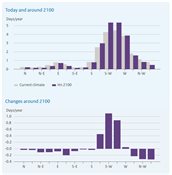
The graph illustrates wind speeds in the North Sea in the current and future climate, under a warming greenhouse gas scenario. It illustrates that future storms are not expected to elevate water levels above average sea level more than at present.
Days per year with wind speed exceeding 14 metres per second at a certain location in the North Sea (coordinates: 53.2°N, 3.2°E), for various wind directions in 1991-2020, and in the Hn scenario around 2100 (top), and the differences between the two (bottom). Source: KNMI (PDF).

Related topics

  • Storm (including blizzards, dust and sandstorms)
  • Cyclone, hurricane, typhoon
  • Tornado
  • Changing wind patterns

Share this
  • Delen op Facebook
  • Delen op LinkedIn

Newsletter

Want to stay informed about the latest developments on the Dutch Climate Risk Portal? Subscribe to the newsletter!

Navigation

  • Climate risk
  • Hazards & Data
  • Tools & Resources
  • Helpdesk

About this website

  • Legal disclaimer
  • Privacy statement
  • Cookies
  • Accessibility
  • Archive

Helpdesk

Do you have feedback, comments or questions about the information on the Dutch Climate Risk Portal? Please use the contact form.