Climate Damage Atlas
The Climate Damage Atlas (in Dutch: Klimaatschadeschatter) is developed for municipal and regional authorities, policy makers, insurers, risk managers and researchers who need to quantify future climate-related losses in financial terms. It is designed for anyone looking to understand the potential costs of inaction on climate adaptation at the local level.
Please note that the figures in the Climate Damage Atlas are now outdated. The last update took place in 2020. This means that the new climate scenarios for the Netherlands have not been incorporated.
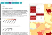
What does the atlas show?
On the portal you can explore estimates of damage costs from pluvial flooding, heat stress and drought for every municipality and for each resident in the Netherlands over the period 2018–2050. The tool breaks down projected losses—such as healthcare costs from heat-related hospitalisations or repair costs for flooded buildings—and includes a calculation of residual flood risk in the primary water system. All results can be viewed interactively on maps, downloaded as tables or exported for further analysis.
Who developed the atlas?
The Climate Damage Atlas is maintained by Climate Adaptation Services (CAS) on behalf of the Ministry of Infrastructure and Water Management, in partnership with several Dutch research institutes.