Sea level rise
The Netherlands has a long history of water management regarding the sea. For example, the Zuiderzee (Dutch for southern sea) was closed off from the North Sea in the 20th century with the construction of the Afsluitdijk, to reduce flood risk and increase freshwater availability.
However, sea levels are rising because of climate change-driven processes: rising global temperatures are causing sea water volume to expand, and the melting of land ice from Antarctica and Greenland is contributing to the increase. Relative sea level rise also includes sinking of soils because of subsidence. The Royal Netherlands Meteorological Institute (KNMI) has calculated (PDF) that sea levels in the Netherlands have risen by 25 centimetres since 1890. Moreover, sea level rise in the Netherlands is accelerating from 1.8 millimetres per year between 1890 and 1993 to 2.9 millimetres per year between 1993 and 2021.
Future sea level rise
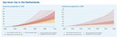
KNMI has also projected future sea level rise for the Netherlands under two greenhouse gas emission scenarios: a low emission and a high emission scenario. These are denoted by the Shared Socioeconomic Pathways (SSPs) (see Dutch climate scenarios for more information).
- Low emission scenario (SSP1-2.6): Global temperatures are projected to rise about 1.7 degrees Celsius by 2100, compared to 1850-1900. This would result in a projected sea level rise of 26 to 73 centimetres along the Dutch coast by 2100, and 16 to 34 centimetres by 2050, compared to 1995-2014.
- High emission scenario (SSP5-8.5): Global temperatures are projected to increase by about 4.9 degrees Celsius by 2100, compared to 1850-1900. This would lead to a projected sea level rise of 59 to 124 centimetres by 2100, and 19 to 39 centimetres by 2050, compared to 1995-2014.
Impact from sea level rise
Higher sea levels result in a higher pressure for flood protection, such as dunes, levees, and storm surge barriers (related to coastal & fluvial flooding). In addition, sea level rise can cause more saline intrusion into land via the coast and rivers. This can harm freshwater supplies needed for agriculture, nature, and drinking water.
To better understand the rate and impact of sea level rise, the Dutch government is conducting research through the Sea Level Rise Knowledge Programme. With this knowledge, the Dutch government can better plan and protect the Netherlands against rising sea levels.